Alaska Statewide Orthoimagery Mosaic
Browse the new Map
Handy things:
- Status map: JPEG status map updated: May 15th, 2013
- Shapefile of source scenes: 2009, 2010, 2011 and 2012 source scenes
- Shapefile of completed ortho tiles: 2010 thru 2012 ortho tiles
- Shapefile of ortho tile layout: ortho tile grid
- Additional download instructions.
- Referencing the data:
- name: Alaska Statewide Orthoimagery Mosaic
- funding credit: Alaska SDMI funding in partnership with the Coastal Impact Assistance Program (CIAP), US Department of Interior and US Fish and Wildlife.
- copyright notice: “includes material © CNES 2013, Distribution Spot Image S.A., France, SICORP, USA, all rights reserved”
- End User License Agreement: SDMI EULA
- Licensed user summary: Fed/Civ, US State/Local government, US Universities, and Tribal non-profits
- Alaska Orthoimagery Mosaic Catalog Record - web metadata record for the project and the web services
- Alaska Orthoimagery Mosaic Browse Map - web map for exploring the orthomosaic products
- Dedicated ortho web map service end point:
- WMS end point: http://wms.alaskamapped.org/ortho
- Web map tile layers library: https://github.com/gina-alaska/gina-map-layers
- Reports
- News
Overview

The Alaska Statewide Digital Mapping Initiative is producing a new statewide orthomosaic, which will provide complete multispectral coverage of the state at 2.5-meter spatial resolution. This satellite image mosaic will be the first consistent, high-resolution, high-accuracy, digital orthoimagery base layer ever produced across the entire state of Alaska.
The orthoimage will be produced to 1:24,000 National Map Accuracy Standards (NMAS) with a CE90 of 12.2-meters. This means that more than 90% of the points will be within 12.2 meters or better of their true location on the Earth. This is an accuracy improvement of at least three times for most existing maps of Alaska. Three statewide mosaics will be delivered: color infrared (CIR), psuedo-natural color, and panchromatic (grayscale). The full land area of Alaska with a 1-kilometer buffer around the coastline and border.
The orthomosaic will be complete by 2014 if the final 2013 collection season goes well. The cloudy weather of Alaska during the 2011 and 2012 collection season has make collecting in-spec source scene imagery a challenge.
The source data is licensed for use by the US public sector and academia at no additional cost. Others can purchase licenses to use the data at a reduced cost. The orthomosaices are publicly available to all US users via Open Geospatial Consortium web services. Please see the license file EULA for details. Contact us for details.
The statewide orthoimagery contract was awarded to Aero-Metric, Inc. Subcontractor Spot Image is providing the source imagery from their SPOT 5 satellite. Subcontractor Fugro Earthdata is performing the image processing, orthorectification, and mosaicing. As prime contractor, Aero-Metric is responsible for overall project management, provision of control and DEMs, and quality assurance. The specifications for the contract can be found in the RFP document.
Schedule
- 2010, 2011, 2012, 2013 source collections completed
- 2010, 2011 ortho tiles completed, accepted, and available for download
- Fall 2013 2012 ortho tile production QA/QC and acceptance
- Winter 2013: begin 2013 ortho tile production
Source data
The source data is the SPOT5 leve1 1A panchromatic and multispectral scene pairs that are used to generate the orthomosaic (ortho tile) products. Preview imagery of source scenes are been created, but these georeferenced browse images are not map products. The browse has been rubbersheeted into approximate locations and not orthorectified or controlled, so they should only be used for previewing the data. See the SPOT5 leve1 1A page for more details.
The first year delivery of source data (2009 and 2010) happened as a large delivery of several hundred scenes that took significant time to review and accept in bulk. Acceptance has was completed and the source scenes added to the browse site. The 2010 ortho tiles are now available from the browse website and the GINA web map and tiles services. The 2011 ortho tiles will be made available for download and through the web services December 2012.
Please read these download instructions regarding how to get access to the SPOT 5 Level 1A satellite imagery data.
Please contact us if you have questions.
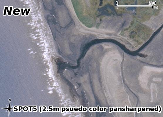
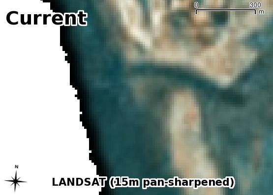
What will it look like?
How is this data an improvement over the existing orthoimagery available statewide–Landsat 7 pan sharpened to 15-meters?
The current statewide color base layer (Landsat 7 natural color, 15-meter spatial resolution):
The new statewide color base layer (SPOT 5 psuedo-natural color, 2.5-meter spatial resolution):